Friday, April 17, 2020

scsvshsstclass4917.040


THURSDAY, APRIL 17, 2020


Lesson 1 ( continued) My Country and It's Landscape. 9/4/2020

PART 5   Lesson  1 ( continued)   My Country and It's Landscape.

9 th April 2020
Good morning boys! Welcome back!πŸ˜ƒπŸ˜ƒ
We continue with the lesson, My Country and It's Landscape.

At the end of the lesson, you will be able to:- 

  •  recall some of the varied landforms which form the diverse landscape of India
  •  label the physical divisions of India
  •  interpret a given map ( match the colour scheme with the corresponding physical  feature)


Hope you are ready for  a short exercise. 
Here we go!

TASK 1 :-    C.W   ( Do it in your rough notebook)

GUESS THE  CORRECT WORD!

  1.  The Great Indian Desert is also known as the --------------- Desert.
  2.   ------------ is the capital of Madhya Pradesh.
  3. A -------------------- is a piece of land surrounded by water on three sides. 
  4.  Jignesh  lives in Ladakh. It is now a state or a Union Territory? ______________
  5.  A  dry area with little or no rain is called a  -------------------
  6.  Anurag lives in  Uttarakhand.  It's  capital is -----------------------
Well done all of you!  πŸ˜€πŸ˜€
---------------------------------------------------------------------
TASK 2 :-  C.W ( Begin  writing the following in your S.St exercise book...we completed till Q 4 )  Written work to be continued.

Q.5.  Define the following terms:-
a. mountain-  a large area of land which  rises above the surrounding land.
b. peninsula- a piece of land that is surrounded by water on three sides.
c. plateau - a raised piece of land with a flat top and steep sides. It is also called a ' tableland'.
d. island- a piece of land surrounded by water on all sides.
e. desert - a dry stretch of land ( hot or cold) with little or no vegetation
f.  coast  - land near the sea.

-----------------------------------------------------------------------------------------------------------------


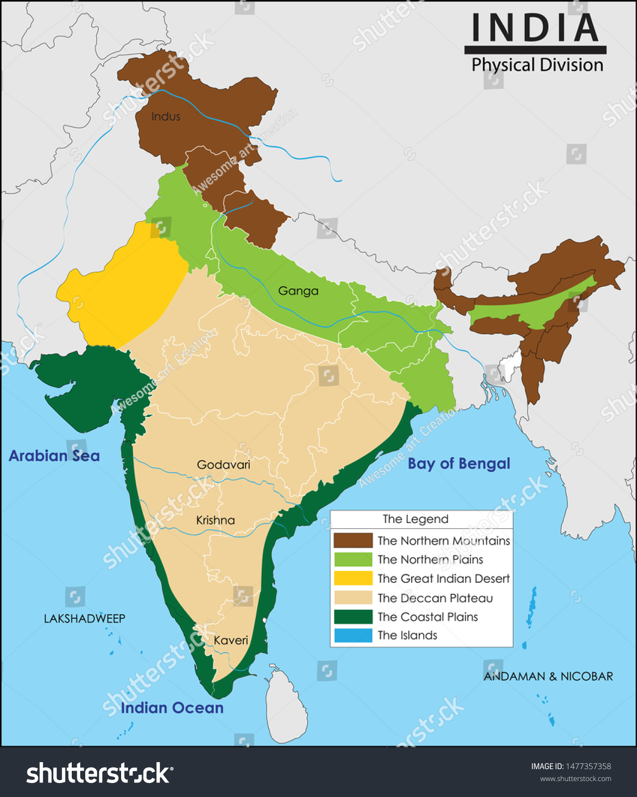
Now carefully look at the map of India given below. It shows the physical features/ divisions of our country.  Keeping this in mind, we will learn to do a bit of  map work today. 

   The  photocopied physical map of India with its physical demarcations will be given to you, once school reopens.   But  now  you  will practice at home looking at  my blog lessons.


GIVEN BELOW IS AN OUTLINE PHYSICAL MAP OF INDIA  WITH THE PHYSICAL DEMARCATIONS .  Look at it carefully. 
 Learn to  label  and  shade  all the six physical divisions neatly. 
 Observe   and  practice  how to  draw the map key shown on the left- hand side of the map attached below:-


REMEMBER!  Only colour pencils to be used for shading. NO crayons will be allowed. 

 1.skkm _N. Mountains
___ _______
2.hhhii __N . Plains

3.hhhh __Western Desert

4. hhhh __Peninsular Plateau

 5.  hhh __Coastal Plains

 6 .hhhh _Island Groups

TASK 3 :-  H.W    (  DO Q. NOS.   A    and  B  on  PAGE NO. 18 of your S.ST TEXTBOOK)    DO THE ANSWERS IN THE READER ITSELF. PLEASE DO NOT COPY IN YOUR FAIR Notebooks. 

 The  expected  answers will be discussed in our next class.
  That's all for today. Stay safe and keep smiling.πŸ˜€ 
Revise all that was done so far and be ready after the Easter break!

Thursday, April 16, 2020

scsvshsstclass4c(16.04)

Ch-1 Q & A

Good Morning boys,

Take out your notebooks and start with a neat & clean handwriting along with the chapter's name and today's date.

Q.1 List the Indian states located along the coast of Arabian Sea.

Ans.  Gujarat, Maharashtra, Goa, Karnataka and Kerala.

Q.2 List the Union Territories of India and their capitals.


Q.3 Name the six major physical divisions of India. Name the physical division in which your state lies.

Ans. India has 6 major physical divisions.

    1. The Northern Mountains
    2. The Northern Plains
    3. The Great Indian Desert
    4. The Peninsular Plateau
    5. The Coastal Plains
    6. The Islands.

Delhi lies in Northern Plains.

Q.4 Name the countries that share their borders with India.

Ans. Pakistan, Afghanistan, China, Nepal, Bhutan, Bangladesh and Myanmar.

Q.5 Name the water bodies that surround peninsular India.

Ans. Arabian Sea in the west, Bay of Bengal in the east and Indian Ocean in the south.


That's all for today!! Do learn all the questions and answers.

Take care! 😊

Thursday, April 9, 2020

scsvshsstclass4c909.4)

PART 5 LESSON 1 (continued) My Country and its Landscape

PART 5   Lesson  1 ( continued)   My Country and It's Landscape.

9 th April 2020
Good morning boys! Welcome back!πŸ˜ƒπŸ˜ƒ
We continue with the lesson, My Country and It's Landscape.

At the end of the lesson, you will be able to:- 

  •  recall some of the varied landforms which form the diverse landscape of India
  •  label the physical divisions of India
  •  interpret a given map ( match the colour scheme with the corresponding physical  feature)


Hope you are ready for  a short exercise. 
Here we go!

TASK 1 :-    C.W   ( PLEASE   TYPE  YOUR  ANSWERS  IN THE COMMENT SECTION BELOW WITH YOUR NAME ) NOT TO BE WRITTEN ANYWHERE .

GUESS THE  CORRECT WORD!
  1.  The Great Indian Desert is also known as the --------------- Desert.
  2.   ------------ is the capital of Madhya Pradesh.
  3. A -------------------- is a piece of land surrounded by water on three sides. 
  4.  Jignesh  lives in Ladakh. It is now a state or a Union Territory? ______________
  5.  A  dry area with little or no rain is called a  -------------------
  6.  Anurag lives in  Uttarakhand.  It's  capital is -----------------------
Well done all of you!  I  appreciate your quick response.πŸ˜€πŸ˜€
---------------------------------------------------------------------
TASK 2 :-  C.W ( Begin  writing the following in your S.St exercise book...we completed till Q 4 )  Written work to be continued.

Q.5.  Define the following terms:-
a. mountain-  a large area of land which  rises above the surrounding land.
b. peninsula- a piece of land that is surrounded by water on three sides.
c. plateau - a raised piece of land with a flat top and steep sides. It is also called a ' tableland'.
d. island- a piece of land surrounded by water on all sides.
e. desert - a dry stretch of land ( hot or cold) with little or no vegetation
f.  coast  - land near the sea.
-----------------------------------------------------------------------------------------------------------------

Now carefully look at the map of India given below. It shows the physical features/ divisions of our country.  Keeping this in mind, we will learn to do a bit of  map work today. 

   The  photocopied physical map of India with its physical demarcations will be given to you, once school reopens.   But  now  you  will practice at home looking at  my blog lessons.


GIVEN BELOW IS AN OUTLINE PHYSICAL MAP OF INDIA  WITH THE PHYSICAL DEMARCATIONS .  Look at it carefully. 
 Learn to  label  and  shade  all the six physical divisions neatly. 
 Observe   and  practice  how to  draw the map key shown on the left- hand side of the map attached below:-


REMEMBER!  Only colour pencils to be used for shading. NO crayons will be allowed. 

 1.skkm _N. Mountains
___ _______
2.hhhii __N . Plains

3.hhhh __Western Desert

4. hhhh __Peninsular Plateau

 5.  hhh __Coastal Plains

 6 .hhhh _Island Groups

TASK 3 :-  H.W    (  DO Q. NOS.   A    and  B  on  PAGE NO. 18 of your S.ST TEXTBOOK)    DO THE ANSWERS IN THE READER ITSELF. PLEASE DO NOT COPY IN YOUR FAIR Notebooks. 

 The  expected  answers will be discussed in our next class.
   Q. C , we will do in our next class. That's all for today. Stay safe and keep smiling.πŸ˜€ 
Revise all that was done so far and be ready after the Easter break!

Wednesday, April 8, 2020

scsvshsstclass4c(08/4)

MY COUNTRY AND ITS LANDSCAPE ( PART 3)

MY COUNTRY AND ITS LANDSCAPE (PART 4)

GOOD MORNING STUDENTS😊😊😊

Today we will be doing the last portion of this chapter.

Once again before the lesson check your previous HWπŸ‘‡

Q 5. What is a physical map?
Ans  A Physical map is designed to show the physical features and landforms of a particular             area.
Q 6. Name the six major physical divisions of India.Name the physical division in which your             state lies.
Ans INDIA HAS 6 PHYSICAL DIVISIONS.These are
  1. The Northern Mountains 
  2. The Northern Plains 
  3. The Great Indian Desert
  4. The Peninsular Plateau
  5. The Coastal Plains
  6. The Islands.
Q 7. Give the importance of the Northern Mountains . (2 points)
Ans The Northern Mountains 
  1. form the northern border of the country
  2. they are the source of many rivers. 
Q 8. Why are the Northern Plains important for our country ?
Ans The land is very fertile so many crops can be grown .
Q 9. What is The Great Indian Desert also known as ?
Ans  It is also known as the Thar Desert

BY THE END OF TODAY'S BLOG YOU ALL SHOULD BE ABLE TO

  • define Peninsula, Island, Plateau
  • give the important features of the 3 physical divisions πŸ‘‡
  • correlate the landforms with the physical map
REMEMBER THISπŸ‘‡


LET'S GET FAMILIAR WITH THE NEXT 3 LANDFORMS namely The Peninsular Plateau , The Coastal Plains and The Islands.

THE PENINSULAR PLATEAU

TASK 1 CW. Please type your answer in the comment box and don't forget to press publish .
______________ is a piece of land surrounded by water on three sides. 
The beige coloured areaπŸ‘†in the map you can see is surrounded by water on 3 sides. 


Deccan Plateau Stock Photos - Download 102 Royalty Free Photos

Main features
    • The light brown portion in the map denotes The Peninsular Plateau.
A Plateau is a landform which is raised above the ground but has a flat top.(its top is flat like a table)
      • It lies to the south of the Northern Plains.
      • The Peninsula is inverted triangular in shape and extends till the southernmost tip of the mainland.
    The Coastal Plains :
    Coast is land near the sea or ocean:πŸ‘‡
     A preserved stretch of coastal plain vegetation in southern Rio de ... 

    Main features

      • The dark green portion denotes The Coastal Plains.
      • The Coastal Plains lie on the eastern and western coasts of the country.
      • In the west, the Coastal Plains occupy the region between the Arabian Sea and Western Ghats.
      • In the east, the Coastal Plains occupy the region between the Eastern Ghats and the Bay of Bengal.

    THE ISLANDS : On the map you can see small blue dots in the seas surrounding the mainland they are islands.

    An Island is a piece of land surrounded by water on all side.πŸ‘‡Get ready for your first-ever railway experience at Andaman and ...

    Main features

    • The blue portion in the map denotes The Islands.  denotes means to show a sign of, to mark or indicate something.
    • India has an island group on its either side.
    • The Andaman and the Nicobar Islands are located in the Bay of Bengal.
    • The Lakhadweep Islands are located in the Arabian Sea.
    Now let us put all the divisions together and revise them by watching the VIDEO belowπŸ‘‡

    That's all for today boys. 

    Just Read the entire lesson for HW


    Bye and Take Care. πŸ˜‡πŸ‘‹


    Saturday, April 4, 2020

    scsvshsstclass4c(04.4)

    My Country and Its Landscape ( Part 2)

    MY COUNTRY AND ITS LANDSCAPE (PART 3)

    Good Morning Students and Welcome back😊

    Now that we know about the political divisions of India we need to move on. 

    Today we will be learning about the physical features of India (Page 16 upto The Great Indian Desert)

    At the end of today you all should be:
    • define physical map, mountains, plains, desert
    • list the six physical divisions of India
    • identify different landscapes in a picture
    • describe the first 3 physical divisions.

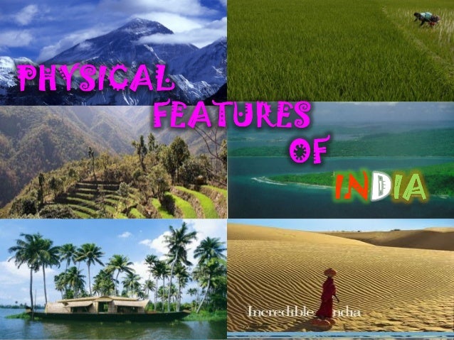
    Look at the picture below πŸ‘‡. Observe that the type of landforms are very different from each other . 

                          physical features of india

    TASK 1 CW

    Type in the comment box what you see in the above picture πŸ‘†

    If you want to find out which type of landscape is in which part of India you would have to look at a PHYSICAL MAP of India . A Physical map is designed to show the physical features and landforms of a particular area.

    NOW Look at the Physical map of India given below and try to find out which landform in the picture is related to which part in the map.

    Vector Illustration India Map Physical Division Stock Vector ...


    You are brilliant if your answers are the same as mine:


    1. Top left picture ( mountains)= Brown shaded area in the map ( The Northern Mountains)
    2. Top right pic (plains) = Light green shaded area in the map ( The Northern Plains)
    3. Bottom left ( Coastal Plains) = Dark green shaded area ( The Coastal Plains)
    4. Bottom right ( Desert) = Yellow shaded area ( The Great Indian Desert)
    5. Middle left ( The Peninsular Plateau) = The Peninsular / Deccan Plateau which is shaded in Beige
    6. Middle righting the pic( land surrounded with water ) = Blue shaded dots in the oceans ( The Island)

    So now we can say that INDIA HAS 6 PHYSICAL DIVISIONS.
    These are
    1. The Northern Mountains 
    2. The Northern Plains 
    3. The Great Indian Desert
    4. The Peninsular Plateau
    5. The Coastal Plains
    6. The Islands.
    Now let us learn a little more about the first 3 of the above divisions:-

    The Northern Mountains: Notice the peaks πŸ‘‡

    Great Himalayas | mountain range, Asia | Britannica

    Mountains are large conical landforms which rise above the surrounding land and have a peak.

    Main features

    • They are the highest mountain range in the world.
    • form the northern border of the country
    • are the source of many rivers. ( many rivers start from these mountains as the snow on them melts to form these rivers. You could read about GLACIERS)

    TASK 2 CW.

    Type the names of some rivers you know which start from the Northern Mountains .

    The Northern Plains :

    Plains are broad areas of flat land. Like thisπŸ‘‡

    The Great Plains - YouTube 

    Main features

    • They lie to the south of the Northern Mountains.
    • the land is very fertile so many crops can be grown .

    The Great Indian Desert :

    Cultural Heritage of the Thar Desert and the Tourist Places in ...

    Main features

    • It is also known as the Thar Desert.
    • it spreads over the north-western part of India.
    • it is a dry sandy area which receives very little rainfall.


    Now let's get ready for some HW

    Continue doing these questions in your S.St notebooks
    Remember to draw a line after every answer:

    Q5. What is a physical map?

    Q6. Name the six major physical divisions of India.Name the physical division in which your state lies.

    Q7. Give the importance of the Northern Mountains . (2 points)

    Q8. Why are the Northern Plains important for our country ?

    Q9.What is The Great Indian Desert also known as ?

    That's all for today boys. Hope you all are working hard.πŸ˜‡

    Friday, April 3, 2020

    scsvshsst4c(03.4)

    My Country and Its Landscape ( Part 1 contd)

    My Country and Its Landscape ( Part 1 contd)

    Good morning and Welcome back πŸ˜„

    For those attending the period just now please type your name and R.No immediately in the comment box below and publish it.

    So I do hope you tried to locate all the States & Union Territories along with their Capitals on the Map while going through the previous blog. 

    Today we will do some written work in our S.St interleaved notebooks.
    Hope you all have got your set of books and notebooks.

    For those who don't have please do all the work in your rough note book and you can fair it out when you get your notebooks.

    Now open your S.St interleaved notebook.
    • leave the first page for the index.
    • on the second page write the date on the top left side of the margin , then write the Name of the lesson on the first line. Underline it neatly using a colour pencil and a ruler.
    • Now begin doing your work neatly in  cursive writing.
    Your notebooks will be corrected once school reopens. Do your work neatly as notebooks will be evaluated and marks will be given for that in both the terms. 

    Now do the following questions and answers in your notebooks:-
           Q1. Write the important features of our country.

        Ans 1. The main features of our country are:-

      1. India lies in the southern part of Asia which is the largest continent . 
      2. it is the seventh largest country in the world
      3. it is the second most populated country in the world.
      4. distance from North to South is 3,214 km and from East to west it is 2,993 km.
      5.  it is surrounded by water bodies (oceans) on three sides.
      6. it shares its borders with Pakistan, Afghanistan , China, Nepal, Bhutan , Myanmar and Bangladesh. 


          Q2.  Define the terms i) Union territory  ii) Political map


       Ans 2. UNION TERRITORIES are regions that are directly ruled by the Central Government.

                  POLITICAL MAP: A political map is a map which shows boundaries, States, Capital of                    states, location of major cities and major water bodies of a region.


         Q3.  How many States and Union Territories has India been divided into?

       Ans 3. India was divided into 29 States and 7 Union territories. (But last year the State of
                 Jammu and Kashmir was changed to a Union Territory) . 

         Q4.  List all the States and Union Territories of India along with their Capitals.

                                 What are the capitals of all states in India? - Quora
                                 What are the union territories of India? Why are they classified ...
      Please don't copy the names of Governors and Official language given in the above table in your note books.

      That's all for today dear boys. Keep smiling 😊


      Wednesday, April 1, 2020

      class4csst my countryand its landscape part 1(01.4)

      L-1 MY COUNTRY AND ITS LANDSCAPE (PART 1)

       Good Morning Students 😎
      TIME : 10:40 - 11:20

      For those attending the period just now please type your name and class/sec. immediately in the comment box below and publish it.

      Welcome to a new and exciting way of learning at home. By now you must be a little familiar with how we are going to study until school reopens. Believe me we teachers too want school to reopen as soon as possible as we miss our classroom atmosphere.

       NOW πŸ‘‰The things that you will need for the S.St lessons are :-
      • your S.St Reader
      • a neatly covered interleaved notebook( a notebook with alternate ruled and blank pages) with your name label in the front.
      • pencil box with essential stationery inside
      • a set of colour pencils.
      As you read through the contents of this lesson please note that:
      • the text in blue will be taken down (copied) as it is in your notebooks
      • the text in pink deals with new information to be taken down in your diary as new word, facts etc
      • the text in red will be questions you need to answer in your notebooks
      • the text in green you could research( find out more about) on your own.
      • there is a comment box at the end of the page for your queries and doubts. I will respond to those in my next session.
      So let's get ready πŸ™†
      At the end of the lesson you all should be able to:-
      • define the terms Union territory, political map
      • give the meaning of continent, government
      • list the important features of our country
      • recall all the states and union territories of India along with their capitals.
      Image result for world map showing india
      Look at the world map above and note the following:-
      So now let's see what the main features our country are:-
      • India lies in the southern part of Asia which is the largest continent (a large land mass separated from other land masses by oceans ). 
      • it is the seventh largest country in the world
      • it is the second most populated country in the world.
      • distance from North to South is 3,214 km and from East to west it is 2,993 km.
      • observe that it is surrounded by water bodies (oceans) on three sides.
      • it shares its borders with Pakistan, Afghanistan , China, Nepal, Bhutan , Myanmar and Bangladesh. 
      INDIA'S NEIGHBOURS
                                                Image result for india's neighbouring countries on map


       Now the question Why is India divided into 28 States and 8 Union territories ? arises in our mind. 
      * Just read the last paragraph on page 14 and try to answer it .
      Now you know that the country is divided so that it can be ruled easily and properly by the Government (a big group of people who are chosen by us to rule the country).

      GOVERNMENT which controls all the Union Territories and coordinates the functions of all the states is the Central Government which is headed by the President, Prime Minister and other ministers.
      Government ruling the states is the State Government.

      States are regions or parts of our country which are ruled by the state government.
      UNION TERRITORIES are regions that are directly ruled by the Central Government.

      Yes I have mention 28 States and 8 Union territories because Jammu and Kashmir is no longer a state it is now a Union territory. Please make that change in your table on page 15.

      I'm sure you all recall that New Delhi is the Capital of our country.  

      If you want to find out where all these states and union territories are located you need to look at a POLITICAL MAP. A political map is a map which shows boundaries, States, Capital of states, location of major cities and major water bodies of a region.

      RECALL the meaning of Capital : It is the city or town that functions as the seat of government and administrative centre of a country or region.

      Look at the political map of India and note where all the States and Union Territories are located. 
                            Image result for political map of india
      Also look at the table on page 15 and see whether you have been able to locate all the states and union territories along with their capitals.

      Read both Page 14 and 15 thoroughly Once Again.

       That's all for today. Keep smiling and Stay Safe πŸ˜‡

      scsvshsstclass4ch.hw

      HURSDAY, MAY 21, 2020 SST HOLIDAY HOMEWORK    ✐✎HOLIDAY HW ✐✎  TAKE IT IN A GOOD SPIRIT.JUST LIKE REVISION MRS. SHEEL...